
A detailed map of the Assyrian Empire, one of my favourite historical topics, at its greater expanse in 750-625 BCE. The map notes the limits of the empire during the reign of Sargon II (specifically in 720 BCE) and under Assurbanipal (in 640 BCE).
Ιστορικές Αναδιφήσεις® _ Περικλής Δεληγιάννης
21/12/2020
Uncategorized ancient Egypt, Assyrian Empire, Assyrians, Egypt, Israel, Judah, Lydia Leave a comment
A detailed map of the Assyrian Empire, one of my favourite historical topics, at its greater expanse in 750-625 BCE. The map notes the limits of the empire during the reign of Sargon II (specifically in 720 BCE) and under Assurbanipal (in 640 BCE).
25/06/2020
Uncategorized Assyria, Assyrian Empire, Assyrians Leave a comment
06/05/2019
Uncategorized Arab, Arabs, Aramean, Assyrian Empire, Assyrians, Edom, Israel, Israeli, Jordan, Moab, Palestine, Philistines, Phoenicians, Syria Leave a comment
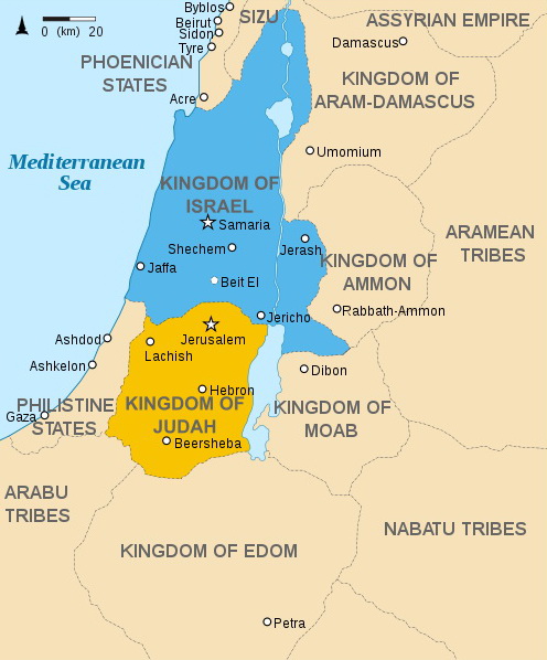
An interesting map of ancient kingdoms, city-states and tribes in the area of south-west Fertile Crescent, 9th-8th centuriesBC. It is supposed to present specifically the kdms of Israel and Judah, but another interesting feature is
More
04/12/2017
Uncategorized Ancient Engineering, Ancient warfare, Architecture, Assyria, Assyrians, Engineering, Μηχανική, urban planning Leave a comment

Plan of the citadel of Dur-Sharrukin (Khorsabad).
More
Some time now I’m contributing to Slingshot, the research Journal of the Society of Ancients (published since1964)


Delving into History® / Periklis Deligiannis / Ιστορικές Αναδιφήσεις® / Π.Δεληγιάννης


