
A map depicting the world of the Hittites, that is the names of states, kingdoms, places, cities, peoples, islands, etc, which are noted on the tablets found in the Hittite capital Hattusas (in the center of Asia Minor on the map).
Ιστορικές Αναδιφήσεις® _ Περικλής Δεληγιάννης
02/08/2021
Uncategorized Achaeans, Anatolia, ancient Egypt, Ancient warfare, Asia Minor, Cyprus, Hatti, Hattusas, Hittite, Hittite empire, Hittites, Military history, Military technology, Troy Leave a comment
A map depicting the world of the Hittites, that is the names of states, kingdoms, places, cities, peoples, islands, etc, which are noted on the tablets found in the Hittite capital Hattusas (in the center of Asia Minor on the map).
22/10/2018
Uncategorized Anatolia, Asia Minor, Bronze Age, Ephesos, Hittite empire, Hittites, Iron age, Lydia, Miletos, Persia, Persians, Phrygia, Smyrna, Trojans, Troy Leave a comment

These are some political maps of the Phrygian and Lydian kingdoms at their greatest extent in the 8th and 6th centuries BC respectively. These two kdms were a kind of “Little empires” of the Anatolian Iron Age that appeared some centuries after the fall of the main Bronze Age empire of Asia Minor that is the Hittite Empire (the last map). The Phrygians were actually invaders from the Balkan Peninsula, kinsmen of the Thracians, the Greeks and possibly the Homeric Trojans. In the Balkans they were known as ‘Brygae’. They were actually a group of tribes, one of which was probably the Proto-Armenians. The main body of the Phrygians settled in an area that included the old Hittite heartland. Gordion and Midas city were their capital cities, and their main sanctuary was at Pessinus.
11/10/2018
Uncategorized Alasiya, Asia Minor, Cyprus, Egypt, Egyptian, Hattusa, Hittite, Hittites, Keftiu, Millawanda, Mycenaeans, Pharaonic, Troy, Wilusa Leave a comment

A map of the Hittite Empire as a prelude to an upcoming article . In red colour, the core territory of
10/09/2018
Uncategorized Anatolia, Bronze Age, Hittites, Mycenaean 1 Comment
Republication from newscientist.com

The Trojan War was a grander event than even Homer would have us believe. The famous conflict may have been one of the final acts in what one archaeologist has controversially dubbed “World War Zero” – an event he claims brought the eastern Mediterranean Bronze Age world crashing down 3200 years ago.
And the catalyst for the war? A mysterious and arguably powerful civilisation almost entirely overlooked by archaeologists: the Luwians.
By the second millennium BC, civilisation had taken hold throughout the eastern Mediterranean. The Egyptian New Kingdom coexisted with the Hittites of central Anatolia and the Mycenaeans of mainland Greece, among others.
30/09/2015
Uncategorized Achaeans, Ancient warfare, Architecture, Asia Minor, Engineering, Hittites, Military architecture, Military history, Military technology, mycenaean civilization, Mycenaeans, Trojan Horse, Trojan War, Troy 2 Comments
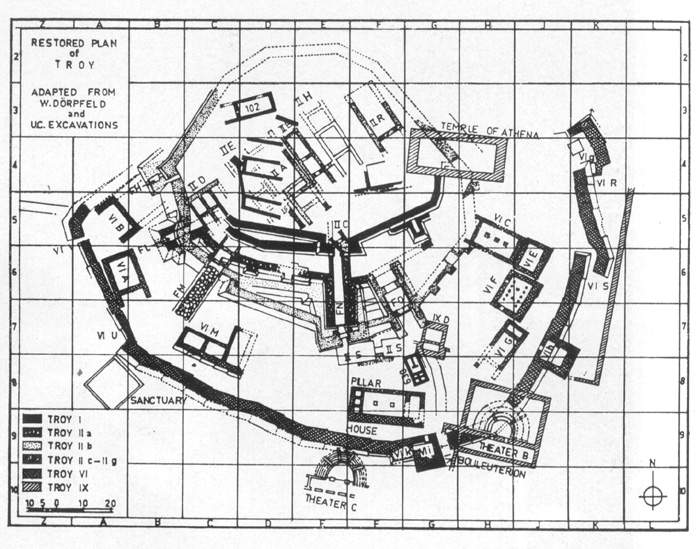 Restored Plan of Troy’s citadel adapted from W. Dorpfeld’s excavations. The successive archaeological and urban levels are noted. Note also the outer and inner walls of Troy VI.
.
By Periklis Deligiannis
.
My initial intention was to give an outline of the military architecture of Troy but the detailed studies of W. Dorpfeld, M. Wood, H. Schliemann, R. Neumann, C.W. Blegen, J.L. Caskey, M.Rawson, M. Korfmann, D. Easton and others, most of which are free on the internet, does not leave any room to add something new to the subject beyond the usual data. Therefore, in this article I will deal with the essential result of that architecture, namely the difficulty of conquering the mighty fortress which Troy VI had been.
Which of the archaeological urban levels of the city discovered and excavated by H. Schliemann at the hill of modern Hissarlik was the city of Homer’s epic? This is one of the main problems concerning the Homeric Epic Cycle. It is considered certain that the Homeric Troy corresponds to one of the levels VI (about 1900-1250 BC) and VIIa (about 1250-1180 BC). Wilhelm Dörpfeld who in 1893-94 continued Schliemann’s excavations in Troy, indicated level VI as the Homeric city. Dörpfeld found that the last phase of that level (VIh) was hit by an earthquake and concluded that after the blow, the city was captured by enemies who according to his view they were the Homeric Achaeans. The German archaeologist found that the earthquake caused damage to the city but the destruction was the work of man, a view based on the discovery of extensive fire traces in the VIh destruction level and on archaeological evidence, mainly traces of military activity.
This theory of Dörpfeld and those who agree with him today (e.g. M. Wood and others) is the most believable in my opinion, that is why in this article I will base my analysis on the assumption that Homer’s Troy was the archaeological level VI (phase VIh). In a future article I will deal with the arguments of those who argue that Homer’s city was the level VI and the ones of those who argue that that city was level VII (less likely).
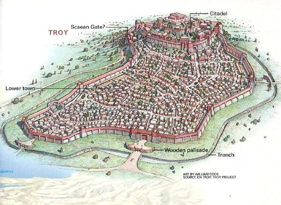
A rare and detailed representation of the total city of Troy (urban area and citadel). Most of the modern representations use to deal just with the architectural and engineering status of the citadel. Most of the defensive features mentioned in the text are noted, but please observe notably the scalar urban distribution of the buildings of the lower city and the citadel, essentially being the fourth defensive line of Troy (Copyright: National Geographic Magazine. Art by William Cook. Source on Troy: Troy project).
Some time now I’m contributing to Slingshot, the research Journal of the Society of Ancients (published since1964)


Delving into History® / Periklis Deligiannis / Ιστορικές Αναδιφήσεις® / Π.Δεληγιάννης

